
Evaluating Florida Gulf Coast Vulnerabilities as Critical Environmental Infrastructure Failures
Florida”s Gulf Coast should treat recurring storm surge, shoreline retreat, and tidal flooding as infrastructure vulnerabilities, not as isolated weather incidents. Each event tests the same underlying systems: sediment supply, drainage, shoreline elevation, wave exposure, and the capacity of wetlands to recover between disturbances. When those systems are already degraded by channels, fill, hardened edges, or disrupted freshwater flows, a storm can convert gradual ecological decline into rapid physical failure. The operational question is therefore not simply whether a shoreline can withstand one storm, but whether it can repeatedly absorb energy, retain elevation, and recover without escalating maintenance costs.
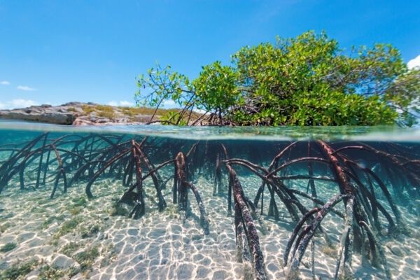
Rigid seawalls provide a clear boundary, but they do not eliminate wave energy. Reflection from concrete or sheet-pile faces can intensify turbulence at the wall base, accelerate tidal scouring, and deprive adjacent wetlands of the shallow, irregular edge needed for sediment capture. A living shoreline offers a different security model. Mangrove stems, roots, and accumulated organic matter create a distributed barrier that slows water before it reaches vulnerable uplands. Properly designed restoration is not cosmetic landscaping. It is self-repairing physical infrastructure that can grow, trap sediment, and adjust its roughness as hydrodynamic conditions change.
The Tri-Species Defense Array and Hydrodynamic Attenuation
Florida”s mangrove defense is built around three principal species whose structures occupy overlapping but distinct portions of the intertidal profile. Rhizophora mangle, the red mangrove, is commonly associated with the seaward fringe. Its characteristic prop roots elevate trunks above soft substrates and create a dense three-dimensional lattice across the tidal boundary. Avicennia germinans, the black mangrove, often occupies slightly higher or more landward ground and develops pneumatophores, vertical root projections that extend above the sediment and permit gas exchange in oxygen-poor soils. Laguncularia racemosa, the white mangrove, generally occurs farther landward or in higher intertidal settings, where its root and canopy structure adds additional roughness and substrate stabilization.
These zones should not be treated as interchangeable planting palettes. Prop roots interrupt flow through repeated obstructions, while pneumatophores increase the density of small-scale roughness near the bed. The resulting friction reduces current velocity and spreads incoming wave energy across stems, roots, and sediment rather than concentrating it at one hard face. Research on mangrove sedimentation found that the combined Avicennia and Rhizophora interphase trapped more sediment than either zone alone, illustrating why mixed structural profiles can outperform uniform stands. Rigorous baseline assessments of nature-based coastal defenses, including research published on mangrove resilience under hydrodynamic change, are essential before transferring performance expectations from one site to another.
| Species and structure | Primary engineering function | Operational considerations |
|---|---|---|
| Red mangrove, prop roots | High three-dimensional flow resistance and edge stabilization | Best suited to frequently inundated seaward margins, provided wave exposure and substrate conditions are appropriate |
| Black mangrove, pneumatophores | Dense near-bed roughness and sediment interception | Supports elevated intertidal zones and can tolerate substantial salinity, but requires adequate drainage around root fields |
| White mangrove, branching roots | Landward transition stabilization and habitat continuity | Useful in higher intertidal areas where hydroperiod, salinity, and elevation support establishment |
Salinity tolerance is not a single pass-fail metric. It interacts with inundation frequency, porewater chemistry, freshwater inputs, soil elevation, temperature, and seedling age. A planting plan that ignores those variables can produce early mortality even when the selected species is broadly described as salt tolerant. The practical design objective is a layered array with species matched to elevation and hydroperiod, allowing roots to develop before the site is exposed to the full force of a major storm.
Mechanisms of Hydrodynamic Energy Dissipation and Sediment Accretion
Mangrove hydrodynamics operate through a sequence of small energy losses that produce a large system-level effect. As tidal water enters a forest, trunks, branches, prop roots, and pneumatophores increase boundary friction and generate turbulence. Flow becomes slower and more heterogeneous, allowing suspended particles to remain temporarily in the water column during inundation and settle as velocity falls near low tide. Research examining mangrove-lined and non-mangrove banks found substantially slower flow and higher suspended-sediment concentrations in the vegetated area. The process can be understood as a filter: water continues to move, but the sediment transport capacity declines.
Accumulation of mineral and organic material builds what coastal engineers often call elevation capital, the vertical margin between the wetland surface and damaging inundation thresholds. That capital is valuable because it can offset part of relative sea-level rise, although it is not unlimited. Subsidence, compaction, reduced sediment supply, excessive erosion, and rapidly accelerating water levels can overwhelm vertical gains. Dense root matrices also bind the upper substrate and reduce the likelihood that ebb-tide suction will remove newly deposited material. Monitoring must therefore measure both surface deposition and deeper elevation change, since apparent accretion at the surface can coexist with subsurface compaction.
- Vegetation increases hydraulic roughness and reduces average flow velocity.
- Lower transport capacity encourages suspended particles to settle during falling tide.
- Root networks bind sediment and reduce bed erosion during ebb flows and moderate wave attack.
- Organic production contributes material to the soil profile alongside imported mineral sediment.
- Marker horizons and surface elevation tables distinguish true elevation gain from short-term surface deposition.
Mangroves generally accelerate sedimentation where hydrodynamic conditions and sediment availability already support deposition; they do not automatically create sediment in a sediment-starved basin. That distinction matters for project screening. A forest planted in an exposed location with little incoming sediment may survive while providing limited elevation gain, whereas a restored wetland connected to a functioning estuary can progressively strengthen its own foundation.
Engineering Living Shorelines Through Standardized Project Classifications
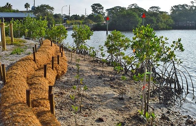
A reliable living shoreline begins with system design, not planting density. Mangrove restoration should be integrated with hydrologic connectivity, tidal exchange, upland drainage, and, where necessary, offshore sills or other wave-attenuation elements. A sill can reduce incoming energy during establishment, but it must be designed to avoid blocking fish passage, trapping pollutants, or interrupting the sediment pathways needed by the wetland. The preferred configuration is often hybrid: natural vegetation performs the long-term work while carefully limited structural elements protect the planting zone during its vulnerable early years.
Project teams also need a common classification system so that objectives, permits, materials, and performance measures are not confused. Gulf initiatives distinguish habitat restoration, hydrologic connectivity restoration, recreational enhancements, and water-quality infrastructure improvements. The Gulf project type framework is useful because it recognizes that a mangrove planting, a culvert replacement, an oyster reef, and a wastewater upgrade produce different outcomes and require different evidence of success. A single shoreline project may contain several categories, but each component should retain its own design basis and monitoring criteria.
- Habitat restoration: mangrove, marsh, seagrass, beach, dune, and living shoreline work supported by appropriate sediment and vegetation measures.
- Hydrologic connectivity: removal of barriers, restoration of channels, or installation of culverts that re-establish natural water exchange.
- Water-quality infrastructure: wastewater, septic, and drainage improvements that prevent pollutants from undermining wetland function.
- Access and recreation: boardwalks, trails, ramps, and other facilities designed to avoid trampling and root-zone damage.
Florida”s regulatory environment is also moving toward clearer support for nature-based resilience. CS/CS/SB 302, enacted after approval by the Governor on March 19, 2026, took effect July 1, 2026, and directs the Florida Department of Environmental Protection to develop design guidelines and standards by January 1, 2027. The framework addresses permitting, emergency conditions, exemptions, incentives, aquatic-preserve activities, and green or hybrid green-gray infrastructure. Until agency rules and local requirements are fully applied to a specific site, project sponsors should verify current permitting pathways, aquatic-preserve restrictions, navigation requirements, and construction constraints rather than assuming that a nature-based label removes regulatory obligations.
Four Steps to Operationalize Resilient Shoreline Protection
Operational discipline separates a durable living shoreline from an attractive but fragile planting project. Baseline data should be collected before construction, during establishment, and after major storms. The design should define measurable thresholds for survival, elevation change, channel function, turbidity, and shoreline retreat. It should also identify failure triggers, such as blocked drainage, unexpected scour, invasive vegetation, or a change in salinity that requires corrective action.
- Conduct the hydrodynamic baseline survey. Map shoreline geometry, bathymetry, substrate, wave exposure, current velocity, tidal amplitude, inundation frequency, salinity, and historical erosion. Compare field measurements with storm records and aerial imagery. The goal is to identify the actual energy regime and elevation envelope rather than select species from a generic regional list.
- Correct local hydrology. Re-establish natural flushing channels, remove unnecessary barriers, and repair culverts or drainage structures that restrict tidal exchange. Hydrologic connectivity should be tested across ordinary tides as well as storm conditions. Planting into a poorly flushed basin can create stagnant water, seedling stress, and avoidable water-quality problems.
- Deploy clustered planting protocols. Place species according to elevation and hydroperiod, using clustered plantings to create early-stage baffling rather than scattering isolated specimens across the site. Protect young plants from wake exposure, trampling, and herbivory where necessary. Any sill or hybrid structure should support establishment without severing aquatic passage or sediment movement.
- Implement continuous performance monitoring. Combine telemetry for water level, salinity, temperature, and wave or current conditions with sediment pins, marker horizons, and surface elevation tables. Inspect after storms for toe scour, channel avulsion, plant loss, debris loading, and structural settlement. Post-storm data should drive adaptive maintenance, not merely document damage after the fact.
Monitoring should be tied to decisions. For example, a decline in elevation capital may trigger sediment-source analysis, while persistent turbidity may point to construction impacts, channel instability, or inadequate vegetation coverage. The most useful programs establish a pre-project reference site and maintain consistent measurement locations, enabling managers to distinguish seasonal variability from genuine system failure. Documentation also strengthens future permitting, grant applications, and capital planning by showing which interventions deliver measurable protection.
Securing the Gulf Coast with Verifiable Ecological Armor
Mangrove restoration deserves treatment as engineering-grade biosecurity infrastructure because it protects the boundary between open water and human assets through distributed, measurable mechanisms. Prop roots and pneumatophores dissipate kinetic energy, vegetation slows currents, and root matrices stabilize the substrate while organic and mineral material builds elevation. These functions are strongest when species are matched to site conditions and when restoration is connected to functioning hydrology, sediment supply, and water-quality controls.
Coastal managers and shoreline stakeholders should treat intertidal wetlands as active capital assets, with inventories, condition assessments, performance thresholds, and scheduled audits. A seawall that is reflecting energy into a collapsing shoreline should not be renewed automatically simply because it is familiar. Where site conditions allow, failing hard edges should be evaluated for replacement or integration with adaptive living barriers. The decisive next step is a defensible baseline, followed by a design that can be monitored, repaired, and improved as the Gulf Coast changes.